In retrospective, the idea of hiking a mountain of almost 2000m above sea level, on a remote island in a foreign country, by myself, seems a bit crazy. Maybe I was, even though I went through some light preparations long beforehand during that summer (hiked twice). So on the D-Day of the hike I could no longer turn back and put all my expectations and excitement to waste.
I booked a cab the night before. packed my backpack (a 2L water bottled, 2 brownies, a Ghana chocolate bar, 3 bananas, flip flops, bandaids, dynamo headlamp, whistle), and set my alarm for 4:45am. I slept through the alarm on Wednesday morning at 5:15am, showered and dressed in 15min and waited for the taxi that never came for 5:30am. So I walked out in the early morning that was still the night, and hailed a taxi on the main road.
For 20000KRW he agreed to take me to the beginning of the Seongpanak trail on Hallasan. As the car drove through sleepy villages and started to go up into forest territory, it dawned on me that although I had 2 phones with me, I didn't know the emergency service phone number! Thoughts like "what if I disappear like this, abducted" or "what if something terrible were to happen?" haunted me during the 30min ride. I tried to keep my composure as someone confident who knew what i was doing and trying to keep busy with the phone pretending to send text messages to my imaginary freinds waiting for me at the trail.
When we arrived at the trail entrance, there were a few cars in the parking lot. There was a building with light inside, but the single person inside just waved at me to go ahead. I was left to myself in this vast wilderness and as the clock showed a few minutes after 6:00am and dawn was timidly showing its early lights on the horizon, I transferred the water into the camel bag, threw the bottle away, and wore my headlamp to start my foray in the dark and conquer Hallasan through the 9.7km trail.
The thick forest was very quiet and relatively dark. The trail was clearly marked with ropes on each side, and made of light gravel or planks of wood. On the side of the trail, emergency call booth with location number could be seen every 20m or so. This was very reassuring in knowing this was a well monitored trail. As I started to be at ease, I could hear the silence of the forest as there was no birds chirping yet or leaves rustling with the wind. In the stillness of the morning, the sound of a bumble bee or a fly would be deafening. It was comfortable as there was no wind, no sun, and the path was easy to walk on, with only the sound of my footsteps and breathing to break the silence.
Shortly before 7:00am, I was startled by a deer munching close to the trail, maybe 5m away. I stopped to breathe, tried to take a photo without flash, and waited for it to notice my presence and leave. It was magical encounter after I had spent 1h on my own with the consciousness of being the sole creature in the reduced universe of the forest.A light fog completed the fairy tale setting.
 The encounter put a smile on my face. But a few minutes later another thought quickened my pace and heartbeat :"what other (scarier) animals are there in this place?". It was interesting that my thoughts were so loud. And so my senses heightened as everything in the forest seemed to awake: minute sounds of rustled dead leaves, flights of the early birds, the scraping of my backpack against my back, etc...Eventually I had to consciously block my ears to ignore the sounds and not stop at every sound to check out what it was. After all I had a deadline to reach a destination and stopping to listen was only met with dead silence mot of the time.
I had to read the shelter before noon in order to have a chance to get to the summit, and so I walked on, waving away the occasional buzzing bug. I was aiming a minimum pace of 2km/h (about 10km to do in 5h max), having started early and not wanting to be out of breath yet. The Seongpanak trail was not very steep for the first 5km. As dawn finally broke information posters showed up on the side of the trail, indicating hiking progression and difficulty level. They were very encouraging and mentally prepared me for the steep sections ahead.

As the day progressed and I got used to the peace and calm outside and inside myself for 3h, rythmed by the regular breathing and footsteps, around 09:00am a disturbance came in the form of over hikers. I wasn't annoyed because they were a couple of middle aged hikers (50-55 year old maybe?) but because they overtook me so easily with nods and smiles, without loosing their breath.I was disturbed because I had someone ahead and there was a temptation to break my pace and catch up to them or follow their pace. So I needed extra focus on my breathing and pace. I needed to last the day, not to be first.
Some other hikers overtook me shortly afterward and even engaged conversation, asking "honja?" which I guessed meant "alone" or "by myself". I nodded and they smiled and I eventually came to my senses and explained I was left behind my friends who were ahead of me with a sudden fluency in Korean (+sign language), as my brain suddenly went overdrive and remembered all the vocabulary gathered passively while watching kdramas.
After the first 6km labelled as easy, the gravel and wooden plank disappeared to reveal a trail made of stacked boulder and narrow crevasses to climb through. The real exercises had started and frequent stops were needed to catch up breath, drink water, and admire the gradual change in landscape. More people overtook me and after more than 1h of struggling with almost boulder climbing, my thighs started to be sore. After a proper sit down to eat chocolate and replenish some energy after 4h hike, I resumed the hike step by step, meter by meter until I arrived at the gravel and wood planks trail again, and oh so above the tree tops and clouds.

As bushes and high grases replaced the tall trees, I was happy to wear a hat as the sun started to warm up. Out of nowhere a whole group of people started to arrive behind me and overtook me in a blitz. They were a group of teenagers (17-19 probably) on a school trip, and 80% male. Watching them run up the stairs with just a small bottle of water was astonishing. I sighted like an 80 year old woman nodding at the energy of youth displayed. Older folks wore gloves and full hiking equipment. I could not bring my walking stick but managed to keep my pace and not be disturbed by the crowd ahead or overtaking me. I briefly wondered how long it took them to hike so far as I was starting to reach my 5th hour.
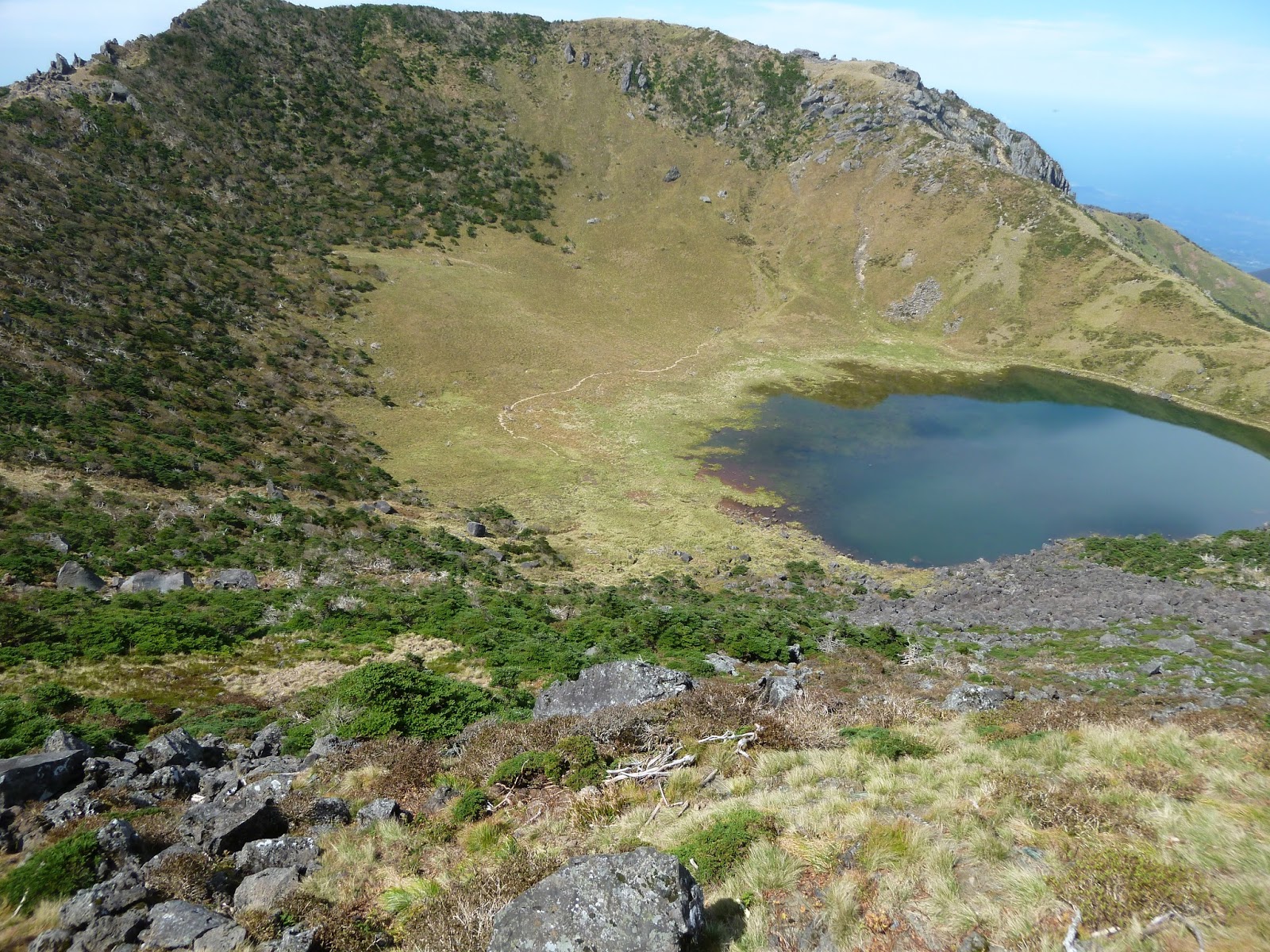
As the summit got closer, and the air rarer, even the bushes became scarce and only rocks and grass could be seen on each side of the path. A helicopter was making trips to being the planks of wood and materials needed to repair the trail.At a certain part the trail had no path and one had to rock climb with chords nailed on the rocks.

On the other side of the island, a city (maybe Jeju city?) and the sea could be seen below cotton clouds.
 Finally after 5h07min climb, I arrived at the summit short breathed, with my feet bloated and hurting, and starving. The feeling of victory, achievement, and relief could not be described and my mind shutdown to safeguard the memory of the previous struggle and to capture that exhilarating feeling of being on top or arrived at destination.
The kids around me were eating their boxed lunch that looked hearty and yummy (rice and banchan/side dishes), while I sat down for a rest, took off my shoes, put on bandaids and wore my flip flops, and unpacked my brownies, bananas and chocolate bar. The view was from another world and I could not wish for more at that time.


After 30min resting and taking pictures with the help of other tourists (there were a few from overseas, like Australia), it was 11:30am and I had to face the climb down. I planned to take the Gwaneumsa trail and try to avoid the crowd.

 The trail down was prettier as well as the mountains and vegetation seemed very luxuriously green and rich. maybe it was the food in my stomach and the excitement that embellished everything I saw from that moment. I was hoping to finish the trail in 3h but it was more difficult and more painful than expected.
One oversight was the fact that it was warmer in the afternoon and there were little shades during the first half of the trail on the way down. Water was running low and the steep slope was taking a toll on the knees and ankles, especially on the part of the trail that had loose gravel or small rocks. Only the wooden plank trail was comfortable as I did not need to focus on where to step on and stabilize my ankles. I caught myself saying out loud "I hate rocks".

After a few hours coming down steps and rocks walking in the valleys on hanging bridges or river beds was a nice change of pace and rest the knees and thighs. Sometimes I had to sit down as my feet were shaking so much from the effort.Even climbing up from the valleys was welcome to use different muscles. I was still getting overtaken by the kids, rolling down the moutain at full speed, running with the music blasting from their backpacks.
The second half of the trail was under the shades of the tall trees, and had some geological, flora and fauna information posters near some viewpoints. After 3h going down from the summit I started to meet hikers on their way up, on their afternoon leisure hike. It gave me hope that the end of the trail would be close.
 As more teenagers overtook me, I heard them encourage each other saying that there was only 1-2km left until the end. I was glad I could count in Korean until 5 to be encouraged by that good news. Somehow going down the mountains did not lift my spirit as much as the hike up. It felt more like a desperate trip to get home by sunset. I did not take into account the fact that my body would be tired and exhausted after 5h hike, and had a difficult time to survive another 4h of physical effort. All my energy was focused on breathing, standing, staying focused on putting my foot on stable ground. Should a dangerous encounter had happened, I had no reflexes left to flee or react..
The trail finally ended on a huge parking lot, and there was a 711 across the stree. I took off my shoes and wore the flip flops again to air my smashed toes, and drank a bottle of chocolate milk and a fruit juice to get fluids and sugar in my system. There was a bus stop on each side of the road but they didn't seem to be any bus running that day, or maybe it was too late. The next bus stop was 40min walk away! There were 4-5 taxis near the 711 and they wanted 20000KRW for Jeju airport or 35000KRW for Seogwipo. I went to Jeju airport and took the counter clock limo for 5000KRW.

I arrived at the hotel for 18:00 and managed to get a sunset view of the Seogwipo bay, and pigged out from local food from the nearby restaurant : seafood, ramen, with no concern for what it was. Then I showered and crashed, somewhat planning for the next day. But my body was numb and only sleep could help.
I booked a cab the night before. packed my backpack (a 2L water bottled, 2 brownies, a Ghana chocolate bar, 3 bananas, flip flops, bandaids, dynamo headlamp, whistle), and set my alarm for 4:45am. I slept through the alarm on Wednesday morning at 5:15am, showered and dressed in 15min and waited for the taxi that never came for 5:30am. So I walked out in the early morning that was still the night, and hailed a taxi on the main road.
For 20000KRW he agreed to take me to the beginning of the Seongpanak trail on Hallasan. As the car drove through sleepy villages and started to go up into forest territory, it dawned on me that although I had 2 phones with me, I didn't know the emergency service phone number! Thoughts like "what if I disappear like this, abducted" or "what if something terrible were to happen?" haunted me during the 30min ride. I tried to keep my composure as someone confident who knew what i was doing and trying to keep busy with the phone pretending to send text messages to my imaginary freinds waiting for me at the trail.
When we arrived at the trail entrance, there were a few cars in the parking lot. There was a building with light inside, but the single person inside just waved at me to go ahead. I was left to myself in this vast wilderness and as the clock showed a few minutes after 6:00am and dawn was timidly showing its early lights on the horizon, I transferred the water into the camel bag, threw the bottle away, and wore my headlamp to start my foray in the dark and conquer Hallasan through the 9.7km trail.
The thick forest was very quiet and relatively dark. The trail was clearly marked with ropes on each side, and made of light gravel or planks of wood. On the side of the trail, emergency call booth with location number could be seen every 20m or so. This was very reassuring in knowing this was a well monitored trail. As I started to be at ease, I could hear the silence of the forest as there was no birds chirping yet or leaves rustling with the wind. In the stillness of the morning, the sound of a bumble bee or a fly would be deafening. It was comfortable as there was no wind, no sun, and the path was easy to walk on, with only the sound of my footsteps and breathing to break the silence.
Shortly before 7:00am, I was startled by a deer munching close to the trail, maybe 5m away. I stopped to breathe, tried to take a photo without flash, and waited for it to notice my presence and leave. It was magical encounter after I had spent 1h on my own with the consciousness of being the sole creature in the reduced universe of the forest.A light fog completed the fairy tale setting.

I had to read the shelter before noon in order to have a chance to get to the summit, and so I walked on, waving away the occasional buzzing bug. I was aiming a minimum pace of 2km/h (about 10km to do in 5h max), having started early and not wanting to be out of breath yet. The Seongpanak trail was not very steep for the first 5km. As dawn finally broke information posters showed up on the side of the trail, indicating hiking progression and difficulty level. They were very encouraging and mentally prepared me for the steep sections ahead.

As the day progressed and I got used to the peace and calm outside and inside myself for 3h, rythmed by the regular breathing and footsteps, around 09:00am a disturbance came in the form of over hikers. I wasn't annoyed because they were a couple of middle aged hikers (50-55 year old maybe?) but because they overtook me so easily with nods and smiles, without loosing their breath.I was disturbed because I had someone ahead and there was a temptation to break my pace and catch up to them or follow their pace. So I needed extra focus on my breathing and pace. I needed to last the day, not to be first.
Some other hikers overtook me shortly afterward and even engaged conversation, asking "honja?" which I guessed meant "alone" or "by myself". I nodded and they smiled and I eventually came to my senses and explained I was left behind my friends who were ahead of me with a sudden fluency in Korean (+sign language), as my brain suddenly went overdrive and remembered all the vocabulary gathered passively while watching kdramas.
After the first 6km labelled as easy, the gravel and wooden plank disappeared to reveal a trail made of stacked boulder and narrow crevasses to climb through. The real exercises had started and frequent stops were needed to catch up breath, drink water, and admire the gradual change in landscape. More people overtook me and after more than 1h of struggling with almost boulder climbing, my thighs started to be sore. After a proper sit down to eat chocolate and replenish some energy after 4h hike, I resumed the hike step by step, meter by meter until I arrived at the gravel and wood planks trail again, and oh so above the tree tops and clouds.

As bushes and high grases replaced the tall trees, I was happy to wear a hat as the sun started to warm up. Out of nowhere a whole group of people started to arrive behind me and overtook me in a blitz. They were a group of teenagers (17-19 probably) on a school trip, and 80% male. Watching them run up the stairs with just a small bottle of water was astonishing. I sighted like an 80 year old woman nodding at the energy of youth displayed. Older folks wore gloves and full hiking equipment. I could not bring my walking stick but managed to keep my pace and not be disturbed by the crowd ahead or overtaking me. I briefly wondered how long it took them to hike so far as I was starting to reach my 5th hour.
As the summit got closer, and the air rarer, even the bushes became scarce and only rocks and grass could be seen on each side of the path. A helicopter was making trips to being the planks of wood and materials needed to repair the trail.At a certain part the trail had no path and one had to rock climb with chords nailed on the rocks.

On the other side of the island, a city (maybe Jeju city?) and the sea could be seen below cotton clouds.

The kids around me were eating their boxed lunch that looked hearty and yummy (rice and banchan/side dishes), while I sat down for a rest, took off my shoes, put on bandaids and wore my flip flops, and unpacked my brownies, bananas and chocolate bar. The view was from another world and I could not wish for more at that time.


After 30min resting and taking pictures with the help of other tourists (there were a few from overseas, like Australia), it was 11:30am and I had to face the climb down. I planned to take the Gwaneumsa trail and try to avoid the crowd.

This trail allowed me to see the profile of the crater and to go through at least 3 valleys on the way down. It was a bit steeper in general than the Seongpanak trail, and there were several parts where it was necessary to climb out of the valleys as well.

One oversight was the fact that it was warmer in the afternoon and there were little shades during the first half of the trail on the way down. Water was running low and the steep slope was taking a toll on the knees and ankles, especially on the part of the trail that had loose gravel or small rocks. Only the wooden plank trail was comfortable as I did not need to focus on where to step on and stabilize my ankles. I caught myself saying out loud "I hate rocks".

After a few hours coming down steps and rocks walking in the valleys on hanging bridges or river beds was a nice change of pace and rest the knees and thighs. Sometimes I had to sit down as my feet were shaking so much from the effort.Even climbing up from the valleys was welcome to use different muscles. I was still getting overtaken by the kids, rolling down the moutain at full speed, running with the music blasting from their backpacks.
The second half of the trail was under the shades of the tall trees, and had some geological, flora and fauna information posters near some viewpoints. After 3h going down from the summit I started to meet hikers on their way up, on their afternoon leisure hike. It gave me hope that the end of the trail would be close.

The trail finally ended on a huge parking lot, and there was a 711 across the stree. I took off my shoes and wore the flip flops again to air my smashed toes, and drank a bottle of chocolate milk and a fruit juice to get fluids and sugar in my system. There was a bus stop on each side of the road but they didn't seem to be any bus running that day, or maybe it was too late. The next bus stop was 40min walk away! There were 4-5 taxis near the 711 and they wanted 20000KRW for Jeju airport or 35000KRW for Seogwipo. I went to Jeju airport and took the counter clock limo for 5000KRW.

I arrived at the hotel for 18:00 and managed to get a sunset view of the Seogwipo bay, and pigged out from local food from the nearby restaurant : seafood, ramen, with no concern for what it was. Then I showered and crashed, somewhat planning for the next day. But my body was numb and only sleep could help.